
|
|
|
National Weather Service issues Flood Watch for Clearwater, Idaho counties National Weather Service has issued a Flood Watch from Thursday evening through Saturday afternoon for portions of central and panhandle Idaho, including Clearwater and Idaho counties. The flooding caused by excessive rainfall is possible. Excessive runoff may result in flooding of rivers, creeks, streams, and other low-lying and flood-prone locations. Creeks and streams may rise out of their banks. Flooding may occur in poor drainage and urban areas. 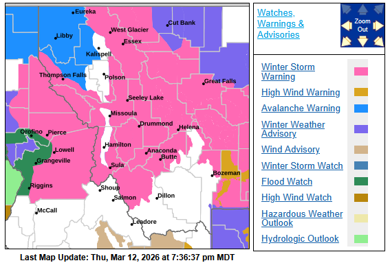 Orofino, elevation 1,039 feet Thursday night: Rain before midnight, then rain and snow. Low around 40 degrees. West wind around 6 miles per hour becoming calm after midnight. Chance of precipitation is 100%. Little or no snow accumulation expected. Friday: Rain and snow. High near 48. Calm wind becoming west northwest around 5 mph. Chance of precipitation is 100%. Little or no snow accumulation expected. Friday night: Rain and snow before 9 p.m., then rain between 9 p.m. and midnight, then rain and snow after midnight. Low around 39. Light and variable wind. Chance of precipitation is 100%. Little or no snow accumulation expected. Saturday: Rain before 9 a.m., then rain and snow. Snow level 3,100 feet lowering to 1,400 feet in the afternoon. High near 47. Light west wind increasing to 9 to 14 mph in the morning. Winds could gust as high as 26 mph. Chance of precipitation is 90%. Little or no snow accumulation expected. Saturday night: A 30 percent chance of snow before midnight. Mostly cloudy, with a low around 28. West wind 6 to 11 mph becoming light west southwest after midnight. Winds could gust as high as 22 mph. Little or no snow accumulation expected. For further details, see: https://www.weather.gov/mso/hydrology. Hydrologic Outlook A prolonged Atmospheric River is expected to impact north central Idaho through Saturday, bringing moderate to heavy precipitation. Snow levels will be ranging from 3,000 to 6,000 feet during the event. The most likely rainfall scenario forecasts 1.25 to 2.75 inches for the valleys of Idaho and Clearwater counties in north central Idaho, and 3 to 5 inches expected in the mountains, but precipitation will be mainly in the form of snow of 2 to 6 feet. The rainfall will increase the risk of rock and landslides across north central Idaho. Continue to monitor the latest forecast updates as this system approaches. The Clearwater River at Orofino is forecast to crest at midnight Sunday at 13.50 feet which is 2.5 feet below the Action stage for flooding, according to the National Water Prediction Service. However, creeks and streams do not have web monitored flows and are often a problem in flooding situations.  |
| Window on the Clearwater P.O. Box 2444 Orofino, ID 83544 Phone: (208) 476-0733 Fax: (208) 476-4140 |