
|
|
|
National Weather Service-Missoula issues more info on Flood Watch National Weather Service-Missoula has issued more info on Flood Watch for Clearwater and Idaho Counties to continue through Thursday. Near-record precipitation is possible this week as two Atmospheric Rivers will move through the region. The first one arrives today and continues through Tuesday, followed by a second, stronger one Tuesday night through Thursday.  Between 4 and 10 inches of moderate to heavy rain are expected in the mountains. For some locations, near record rainfall amounts are possible. The rain, falling on the current snowpack, combined with mild nighttime temperatures will increase snowmelt. Flows in rivers may increase quickly and reach critical levels. Creeks and streams may rise out of their banks. Flooding may occur in poor drainage and urban areas. Storm drains and ditches may become clogged with debris. People, structures, and roads located below steep slopes, in canyons, and near the mouths of canyons may be at risk from landslides. 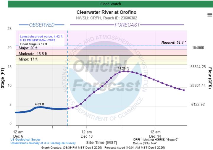 This U.S. Geological Survey graph shows the Clearwater River rising about 9.5 feet during the period. There are no gauging stations on the local creeks and streams. A prolonged atmospheric river is expected to bring periods of heavy rain to Clearwater and Idaho counties, Monday night through Thursday. Rising snow levels will lead to a rain on snow event for elevations below 7,000 feet Monday night into Tuesday morning. The precipitation rates will briefly decrease Tuesday afternoon, before a second surge of moisture arrives Tuesday night into Thursday morning with snow levels rising to near 8,000 feet. By Thursday, significant precipitation totals are forecast, with 2 to 5 inches in the valleys and 5 to 10 inches in the mountains, with locally higher totals over mountain crests. Landslides in areas of steep terrain and minor flooding in urban and poor drainage areas is possible. Precautionary/Preparedness Actions: People should monitor later forecasts https://www.weather.gov/mso/ and be alert for possible Flood Warnings. Those living in areas prone to flooding should be prepared to take action should flooding develop. Monitor basements for water intrusion. People may want to preemptively shovel snow away from their homes. 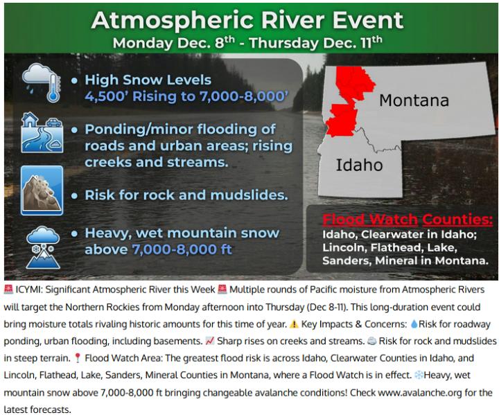   |
| Window on the Clearwater P.O. Box 2444 Orofino, ID 83544 Phone: (208) 476-0733 Fax: (208) 476-4140 |