
|
|
National Weather Service issues Winter Storm Warning, Advisory National Weather Service-Missoula has issued Winter Storm Warning for the Northern Clearwater Mountains and a Winter Weather Advisory for the lower elevations of Clearwater County from Sunday morning through Monday morning. Winter Storm Warning The Winter Storm Warning is in effect from 5 a.m. Sunday to 8 a.m. Monday. Heavy snow is expected with total snow accumulations of 5 to 9 inches. Snow rates at times will exceed one inch per hour. Winds may gust as high as 40 miles per hour. Areas of particular concern are Elk River, Idaho Highway 11 from Pierce to Headquarters and Pierce. Plan on slippery roads and patchy blowing snow that could significantly reduce visibility. Pierce, elevation 3,085 above sea level Saturday night, snow is forecast mainly after 4 a.m. Total nighttime snow accumulations of less than one inch possible. Sunday, snow is expected mainly before 4 p.m. New snow accumulation of 3 to 5 inches is possible. Sunday night, snow is forecast mainly after 10 p.m. with new snow accumulations of 1 to 2 inches possible. Monday, snow is forecast mainly before 4 p.m. with new accumulation of less than 1 inch possible. 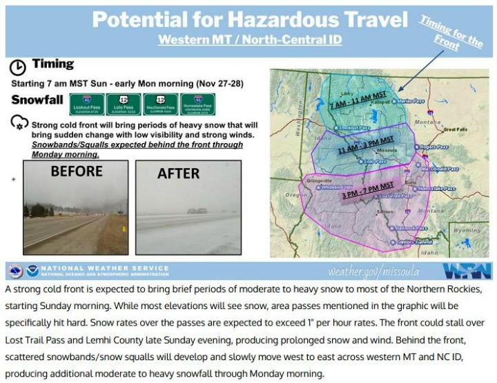 Winter Weather Advisory The advisory is from 9 a.m. Sunday through 8 a.m. Monday. With areas of particular concern being Camas Prairie, Grangeville and vicinity, and Greer Grade. Snow is expected. Total snow accumulations of 2 to 4 inches are possible. Snow rates of 1 inch per hour at times are possible. Winds may gust as high as 45 mph. A brief break in snow is expected Sunday afternoon before periods of moderate to heavy snow showers develop for Sunday night. Orofino, elevation 1,040 feet above sea level Saturday night, snow is possible mixed with rain and freezing rain, mainly after 5 a.m. Snow level is expected to be 1,700 feet. Little or no ice/snow accumulation is is expected. Sunday's forecast is for rain and snow before 7 a.m., then rain between 7 a.m. and 3 p.m., then rain and snow likely after 3 p.m. Snow level at 2,900 feet lowering to 1,600 feet in the afternoon is expected. Winds could gust as high as 30 mph. New snow accumulation of less than a half inch are possible. Sunday night, snow is likely after 11 p.m. with new snow accumulation of less than one inch possible. Monday, snow is likely after 11 a.m. with new snow accumulation of less than half an inch possible. Precautionary/preparedness actions… Those who must travel, keep an extra flashlight, food, and water in the vehicle in case of an emergency. The latest road conditions for the state are available by calling 5 1 1.  |
|
| Window on the Clearwater P.O. Box 2444 Orofino, ID 83544 Phone: (208) 476-0733 Fax: (208) 476-4140 |