
|
|
National Weather Service issues Winter Storm Watch for Clearwater County National Weather Service-Missoula has issued a Winter Storm Watch for both the upper and lower elevations of Clearwater and Idaho counties, along with some other surrounding areas. The Storm Watch is for Thursday evening through Friday morning for the Orofino/Grangeville region and from Thursday evening through Saturday morning for the Northern and Southern Clearwater Mountains. Orofino/Grangeville region Heavy snow is possible with total snow accumulations of one to three inches possible in the lowest elevations, including Orofino and four to eight inches possible on higher benches and grades, including Whitebird Grade. Uncertainty remains with how quickly temperatures will warm above freezing on Friday, which will lead to differences in the snowfall forecast. Wet, heavy snow will increase the risk of tree limb and power line damage. Travel may become difficult on area roads due to slushy conditions. 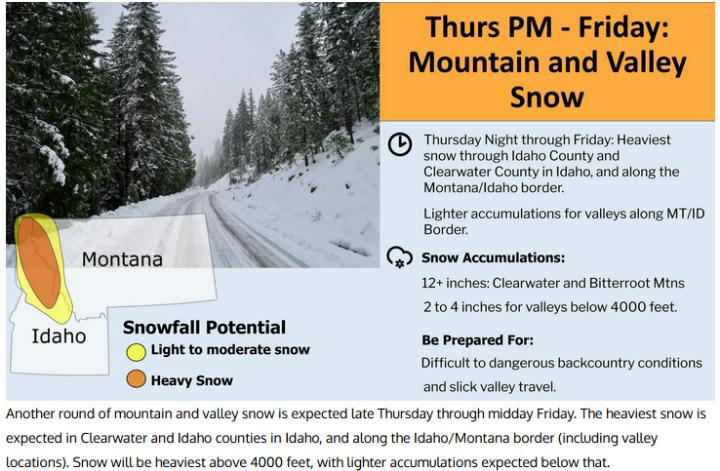 Northern and Southern Clearwater Mountains Heavy snow is possible for all elevations through midday Friday. Heavy snow possible for high elevations through Saturday morning. Total snow accumulations of 3 to 8 inches possible below 4,000 feet. Accumulations of 6 to 12 inches possible above 4,000 feet, including Lolo Pass. The highest terrain could see up to 2 feet of snow. Areas of particular concern are Elk River, Idaho Highway 11 Pierce to Headquarters, Pierce, U.S. Highway 12 Lowell to Lolo Pass, Dixie and Elk City. Periods of heavy snow could lead to hazardous driving conditions. Wet, heavy snow will also increase the risk of tree limb and power line damage. Monitor the latest forecasts for updates on this situation.  |
|
| Window on the Clearwater P.O. Box 2444 Orofino, ID 83544 Phone: (208) 476-0733 Fax: (208) 476-4140 |