
|
|
National Weather Service-Missoula issues Flood Watch National Weather Service Missoula has issued a Flood Watch for portions of North Central and Central Idaho including the Orofino/Grangeville region, the Southern and Northern Clearwater Mountains and Lower Hells Canyon/Salmon Region from 5 p.m. Saturday through Monday afternoon. Excessive runoff may result in flooding of rivers, creeks, streams, and other low-lying and flood-prone locations. Creeks and streams may rise out of their banks. Flooding may occur in poor drainage and urban areas. Rock and mud slides, debris flows, and landslips will be possible during this time. An atmospheric river bringing intense precipitation to the region will occur and result in rising water levels for area streams, creeks, and mainstem rivers. 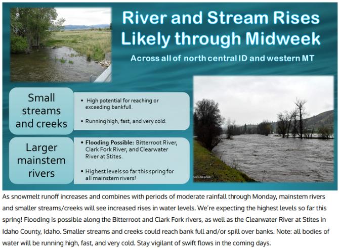 (National Weather Service-Missoula) For flood safety info see: http://www.weather.gov/safety/flood. According to the Advanced Hydrological Prediction Service in Portland, OR, the Main Clearwater River at Orofino is forecast to crest Monday about 5 p.m. at 17.61 feet, just into minor flood stage. However, that forecast continues to be adjusted based on conditions. Below Dworshak Dam, the Clearwater continues to rise from the precipitation, snow melt and increased flows from the reservoir which Saturday morning was only six feet below full pool. The spillway is open and U.S. Army Corps of Engineers plans are to continue the high flows to make room for water coming into the reservoir. Some water was released earlier in the spring to keep the reservoir within the flood curve, but added releases are necessary now. They expect the reservoir to be at full pool, 1,600 feet by June 20. (See the article...) Some flooding is occurring along the South Fork of the Clearwater around Stites.  |
|
| Window on the Clearwater P.O. Box 2444 Orofino, ID 83544 Phone: (208) 476-0733 Fax: (208) 476-4140 |