
|
|
New wildfire near Dixie exceeds 1,000 acres despite aggressive initial attack KAMIAH-Firefighting resources are actively engaged in full suppression operations on the Dixie Fire, located 40 miles southeast of Grangeville and 15 miles South of Elk City near the community of Dixie. The fire is estimated to be between 1,000 and 2,500 acres as of 7 a.m. (Pacific Daylight Time) on July 6. Aviation and ground resources resumed fire suppression operations near Dixie Summit along Forest Service Road #222 early Tuesday morning. 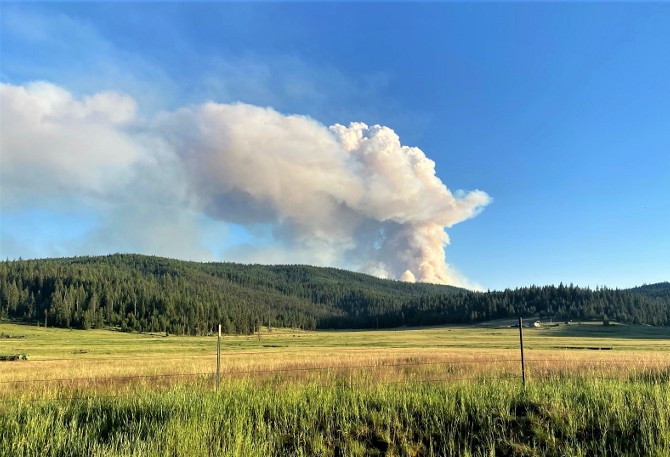 "Multiple helicopters and large retardant tankers worked on the fire from time of detection to the very last possible minute of daylight yesterday (Monday) during initial attack," said Jim Wimer, Public Affairs Specialist for the Nez Perce-Clearwater National Forests. The Dixie Fire was detected in the early afternoon on July 5 by aviation resources that were engaged in suppression operations on a different fire at the time. The cause of the Dixie fire is unconfirmed at this time due to extreme fire behavior near the point of origin, but fire managers believe it was started by lightning from recent thunderstorm activity in the area. Due to the current combination of hot, dry conditions and the accumulations of heavy dead and down fuels, the fire was able to spread rapidly and quickly exceed the capabilities of local aviation and ground resources on scene. A Type 1 Incident Management Team has been ordered and is tentatively expected to assume command of the Dixie fire at 6 a.m. (PDT) on Thursday, July 8. Until that time, the fire is being managed under a local Type 3 organization, with multiple aircraft, crews, engines, and heavy equipment currently assigned. 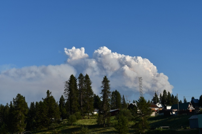 (Photos courtesy of Jim Wimer, Nez Perce-Clearwater National Forests) Temporary flight restrictions were be put in place over the fire area Tuesday for the safety of the public as well as of aerial firefighting resources. Remember, "If you fly, we can't." Please avoid the Dixie area, both on the ground and in the air, while fire resources are working. The Nez Perce-Clearwater National Forests is working closely with the Idaho County Sheriff's Office to evaluate and implement evacuation orders as needed. Nez Perce-Clearwater National Forests fire information is available online at https://bit.ly/NPCFireInfo, on social media at www.facebook.com/NPClwNFs and www.twitter.com/NPClwNFs, on the forest's official mobile app (search "Nez Perce Clearwater" in your app store), or by calling your local ranger station. Report all wildfires to the Grangeville Interagency Dispatch Center (208-983-6800) or call 911. |
|
| Window on the Clearwater P.O. Box 2444 Orofino, ID 83544 Phone: (208) 476-0733 Fax: (208) 476-4140 |